Imagined Maps of the Middle Ages
- EPOCH

- Mar 1
- 9 min read
Victor Temprano │ Erasmus University Rotterdam
Video game maps lie to us, and we love the lies they tell. Open the map in Kingdom Come, Elder Scrolls, or any medieval-themed game and you get the usual charming package: parchment edges, faded ink, hand-drawn trees. It looks quietly, comfortably, archaic.
Though these maps may feel medieval, they think modern. We hardly even notice any incongruity: we take for granted the bird's eye view, the geographic accuracy, and the navigational function. The way we use maps feels natural and timeless to us. Yet our idea of what a map is, and what it does, is not as timeless as we tend to assume.
We can sense this when we turn to the extant sources of the Middle Ages, where we find maps that depict space in a different, sometimes bizarre, manner from what we expect. In fact, the kinds of maps that survive vary so widely in form and purpose that our modern idea of what a map is is difficult to, well, map onto any medieval concept. These were rare, expensive objects, with none of the ubiquitous nature of modern GPS. Before we imagine our video game heroes wandering around with parchment in hand, let's look closer at how medieval cultures mapped the world.
An initial surprise is that, in the Middle Ages, geographic knowledge was only rarely stored in maps at all. Instead, spatial data lived in lists – of boundaries, of trade routes, residences, and landmarks. When maps do appear in the historical record, they represent very different paradigms. A map carved in stone in Tang China has little in common with an Islamic survey on paper or a European mappa mundi on animal skin. Even within Europe, the surviving examples vary widely in form, purpose, and audience.
This diversity reveals that there was no single ‘medieval map’ that stood in for the world the way our more-or-less standard cartographic map does now. Instead, medieval mapmaking was a collection of specialised practices. In Europe – the cultural reference that most strongly shapes the medievalism of today’s games – these practices cluster into three broad types. Each of these forms imagined the world differently, and none of them tried to do all the things we expect our maps to do today.
Mappa mundi

Mappa mundi are the best known of medieval maps, and the easiest to misunderstand. These elaborate works were drawn and illuminated on vellum or parchment, prepared animal skins, sometimes stitched together into sheets several metres across. The most common format shows a circular world divided by water into Asia, Africa, and Europe. Famous mappa mundi examples include the eighth century Mappa Mundi d’Albi, a small, sectioned map, 27 by 22 centimeters in dimension on sheepskin; the thirteenth century Ebstorf Map, an elaborate creation made of thirty goatskins laced together; and the fourteenth century Hereford Mappa Mundi, a roughly 1.5-meter square map on calfskin laid thick with illustrations and descriptive notations.
The effort put into making these maps was enormous. First of all, it was expensive. Obtaining the material, preparing the ink, sketching the diagram, and painting the figures was complex enough, and often required years of training. For the monks who created these maps, even more work came in the preparation and research: compiling lists of places, the consultation and summary of biblical commentary, the referencing of classical geography. These diagrams represent a vast corpus of knowledge of the world and the attempt to synthesize that knowledge in a visual form.
Yet for all this work, the maps seem to us to be almost silly. They are hopelessly inaccurate to our geographically-trained eyes. We can vaguely identify a circle as England, or see the general shape of the Mediterranean, and we tend to estimate the value of these maps based on their supposed accuracy. In reality, this reflects our bias, because for the mappa mundi makers, the goal was never to show the physical world with geometric accuracy. These cartographers were almost always religious men, for whom the ‘real world’ was not physical, but spiritual.
A mappa mundi was a way to both understand and communicate the order of God’s creation. Throughout the medieval period, and especially in the later Middle Ages, there was a growing desire to analyze the world, to comprehend God's universe and the human place in it. We see this in Biblical chronologies, in alchemical research, and in the mappa mundi. They depict the path of salvation, the journeys of saints, or the moral structure of the cosmos. East sits at the top because Eden lies there; Jerusalem occupies the centre because it anchors sacred reality. Creatures, marvels, and biblical episodes spill across the surface. Even known spatial facts could be set aside: the Hereford map, for instance, links the Caspian Sea to the ocean long after reports had established it was landlocked.
Once completed, such maps travelled little. They hung in churches, kept company with chronicles, or served in teaching. They were not aids for navigation, but diagrams of meaning and tools for contemplation.
Portolan Charts

Portolan charts belong to a very different world of mapmaking. They appear relatively late in the medieval period, with the first surviving examples made in the thirteenth century. Yet even early portolans arrive looking remarkably recognizable. Unlike the symbolic mappa mundi, these maps were likely practical tools for sailors navigating between ports. They were made on skins as well, but their lives were very different. A portolan could be folded, rolled, corrected over time, and moved from ship to ship.
To modern eyes, these charts are comprehensible, if busy. They are maps that are closer to our own expectations, with strikingly accurate coastlines and ports labelled in dense lists, giving lie to the notion that medieval people were incapable of depicting space geometrically. The surface of the maps are criss-crossed with straight lines that could help sailors follow compass bearings. Near the end of the Middle Ages, some charts even pick up decorative features – monsters, banners, architectural sketches – that feel, today, like the flourishes in a fantasy game map.
Their accuracy is curious. Portolans are far too zoomed-out to guide a ship into harbour; for that, sailors relied on written or memorised directions listing landmarks, depths, shoals, and hazards. The charts themselves must have been compiled from this kind of practical knowledge, combined with measurements, but the evidence for their development is sparse. It is difficult to say for certain if any examples still in existence today were actively used onboard ships. Some, like a chart of the Mediterranean made in Genoa in the fourteenth century, do seem to be mainly functional, containing coastlines, placenames, and compass lines. Others, like the finely detailed Valleseca Portolan made in 1439, contain dozens of illustrations and rich colors. Most of the surviving portolans today are too large, too ornate, or too finely colored to have served as working tools. Their purpose was likely multivalent: part navigational aid, part record of maritime knowledge, part prestige object displayed on walls.
Interestingly, the one thing they were not were ‘maps’. The English word ‘map’ traces back to mappa mundi. A portolan, by contrast, was likely called a carta nautica – Latin for nautical chart rather than a ‘map’. What we today bundle together as ‘medieval maps’ were, to their makers, likely entirely different in development and utility.
Regional Maps
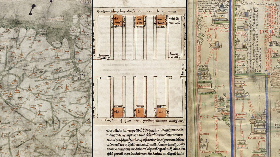
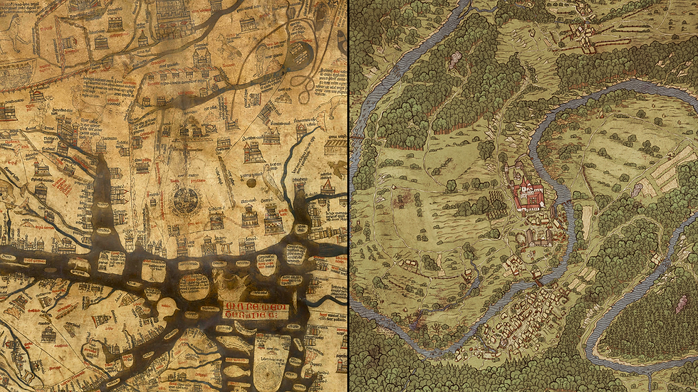
Beyond world maps and portolan charts lies much more cartography – regional diagrams, property sketches, and hybrids that resist neat classification. These objects vary so widely in form and intention that they are perhaps best understood as experiments.
Some of these maps aim at geographic representation, like the early fourteenth century English Gough Map, with its elongated island and measured roads. Others are simpler, like planning documents for architectural work. Many survive as pages inside manuscripts rather than freestanding objects. Others decorated floors, like the eleventh century world map in the chamber of the Countess Adèle of Blois described in a poem by the abbot Baudri of Bourgueil. What unites them is not a shared cartographic logic, but that someone answered their requirements with a picture instead of a list.
From this mixed landscape emerges one particularly revealing form: the medieval itinerary. These were essentially written route lists, turn-by-turn descriptions of how to travel from one place to another, but in graphic representation. In his Chronica Majora, thirteenth century chronicler Matthew Paris produced an extraordinary illustrated journey to the Holy Land, with page after page of towns, rivers, and castles. Today we call it a strip-map, and it does not resemble a modern map so much as a guided story.
No traveller would have used Paris’s itinerary on the road; the manuscript was far too precious. Instead, it supported a practice of ‘virtual pilgrimage’, in which monks followed the journey, step by step, visiting Jerusalem in the mind when they could not in the body. The strip-map was a story to be imagined.
These medieval traditions sit together today as ‘maps’ only because we place them there. In their own time, they were distinct tools, and average people would never have encountered any of them. Cartographers sometimes borrowed ideas across traditions, but that did not make these objects part of a single category.
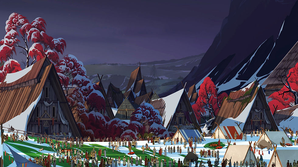
This makes the maps we see in medieval-themed video games especially telling. They compress an enormous variety of medieval practices into a quick visual shorthand: parchment texture, hand-drawn hills, written placenames.

That shorthand also has a modern lineage: J.R.R. Tolkien’s 1954 Lord of the Rings. Influenced by William Morris, by his studies in European history, and by his experience with military maps in the First World War, Tolkien fused geographic plausibility with a hand-drawn, storybook aesthetic. His maps show individual mountains, winding paths, towers, and placenames, all laid over a geography that feels coherent enough to be real. These maps hearken back more to Renaissance maps than medieval ones, but they feel old.
Tolkien's maps offered a hybrid the modern imagination finds irresistible: hand-drawn charm paired with geography that more or less makes sense. These maps looked pre-modern, but they behaved the way we expect a map to behave – coherent, legible, and spatially believable. From Tolkien onward, fantasy maps adopted this look, and it has even become the default pop culture image of any premodern map, whether in Rome or David or Game of Thrones.

Video game maps inherit this hybrid model. Look at the map of World of Warcraft, the maps in Kingdom Come: Deliverance, the land of Elder Scrolls: Oblivion. Each one borrows the hand-drawn charm associated with Tolkien while operating with the precision and expectations of modern cartography. Some are more heavily illustrated than others, but the core conceptual underpinning is the same.
Interestingly, before our technology made it possible for maps to be so complex and ever-present, some role-playing games (RPGs) occasionally worked more like the medieval lists. Morrowind, for example, often gave directions as sequences of landmarks: ‘Follow the road south from Pelagiad, just before the fork where the path bends southwest toward Seyda Neen…’ This itinerary-style navigation – narrative, local, and grounded in spatial awareness – mirrors how most medieval travellers moved through the world. No diagrams, no overview, just connecting one place to another.
Today this experience has largely vanished from games; the map is omnipresent. It is a Swiss-army tool for wayfinding, quest-tracking, and world-building. A world without a map feels incomplete, and a player without GPS feels unmoored. Our games reflect a culture that identifies movement with map – a spatial paradigm so pervasive we rarely notice it.
This type of map use shapes how we imagine the world. Medieval people moved through a land that was rarely abstracted into an image; orientation came from landmarks, stories, and other travellers. A sense of place was built from the ground. Video game maps, by contrast, reveal that we think of land as an abstracted image, not just a place we actually live. These games lie to us exactly the way we want them to, by giving our medieval-themed worlds a map-shaped coherence the Middle Ages never had.
Further Reading:
Humphrey Carpenter and Christopher Tolkien, The Letters of J.R.R. Tolkien: revised and expanded edition (HarperCollins Publishers, 2023).
Evelyn Edson, Mapping Time and Space: How Medieval Mapmakers viewed their World (British Library, 1998).
Stefan Ekman, Here Be Dragons: Exploring Fantasy Maps and Settings (Wesleyan University Press, 2013).
J.B. Harley and David Woodward, The History of Cartography: Cartography in Prehistoric, Ancient, and Medieval Europe and the Mediterranean. Vol 1 (University of Chicago Press, 1987).
Victor Temprano is an independent scholar and digital humanist based in both Canada and Spain. He is the founder of Native-Land.ca and works with maps in commercial and academic settings. As the 2025 Erasmus Collection Fellow with Erasmus University Rotterdam, he recently debuted Erasmiana.org, a semantic digitized corpus of Erasmus. He is working on a wide range of projects, from immersive digital storytelling to development of AI pedagogy.